| About Wallowa Lake Area |
Home Page | Interior Pictures | Exterior Pictures | Cool Word game | High Lake Pictures
| Wallowa Lake sparkles as the most beautiful jewel in the crown of Oregon. Set at the base of the majestic Wallowa Mountains, with crystal high lakes glittering among granite crags to the south, and surrounded by a moat of deep canyons to the north and east, Wallowa Lake waits as a hidden treasure for you to uncover. | 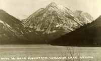 1940s' Postcard of the Lake |
| Ways to explore these majestic mountains You can explore Wallowa Lake's kingdom of beauty in many ways. Your car can carry you high into the forested mountains, and deep into grassy canyons. Then to the brink of the deepest gorge in North America. Each trip is less than 60 miles from Wallowa Lake. Backpacking reigns as a classic trailblazing means. Thread your way along 480 miles of well marked and graded U.S. Forest Service trails that lace the 364,325 acre Eagle Cap Wilderness. Travel the same route, but without taking a step -- on horseback. |
| Little Switzerland of America People are awed by the beauty of the Wallowas, a place like no other. Travelers have compared the character of the Wallowa Mountains to the Alps, nicknaming the area "Little Switzerland of America" and "The Alps of Oregon." In the mid-1980s, scientists showed this is no exaggeration. Twenty species of fossilized coral were discovered in the Wallowa Mountains, and proved to be identical to ancient coral found in the Austrian and German Alps. Some 220 million years ago, the coral reefs in an ancient sea drifted apart via "conveyor belt tectonics". Miles of ocean floor that became parts of the Alps and the Wallowas went seperate directions. The coral has provided a firm scientific basis to the geologic resemblance of the European Alps and the Wallowas. |
| Formed By Glaciers From a million until 15,000 years ago, glaciers moved through the Wallowa Mountain area during the Ice Age (Pleistocene Epoch). The ice receded leaving behind the near-perfect symmetry of two lateral (800 feet high and six miles long) and one terminal moraine that cradle 299 foot deep Wallowa Lake. Today, only the highest Wallowa peaks have glaciers. Geologic activity left a rich legacy to 3,178 square mile Wallowa County, including the highest lake in Oregon. Between elevations extremes, 1000 feet at Snake River to 9845 feet at Matterhorn Peak, there are many climatic zones. |
| Seasons at Wallowa Lake At Wallowa Lake, seasons bring great variety. Summer temperatures reach into the 90s with lows in the 40s. Winters are often "old-fashioned" with thermometers plunging to -10. Wallowa Lake can freeze with foot-thick ice, inviting skaters to its six mile length. Bolder (??) folks have driven lighter cars onto the ice. Some brave aviators have landed small airplanes on the frozen lake. Accommodations are available in the winter. Conferences, reunions, honeymooners, cross country skiers and snowmobilers are discovering the winter wonderland. Spring returns. By July 4, most high country wilderness trails are snow-free and remain open until about October. September weather is predictably splendid, the warm Indian sunshine bring ablaze the glorious golden aspen and tamarack. The pace of nature and activity at Wallowa Lake is slower providing a peaceful holiday with all services available through Alpenfest. |
| Native American History - What's a Wallowa? In the mid-1800s, white visitors found the friendly Wallowa Band of the Nez Perce led by Old Chief Joseph. (A treaty in 1855 gave the Wallowa country to the Nez Perce.) Old Joseph died in 1871, and Young Joseph became chief of the Wallowa hand. Joseph's people shared their Wallowa home land with settlers. Every winter, Joseph led his people into milder canyons northeast of the Wallowas. Summer brought them back to the lake to fish, hunt and raise horses. To fish for trout and salmon, a tripod of poles was set on opposite streambanks. Between the tripods a special network of poles extended into the water. Fish were trapped by the poles, and caught by hand. The Nez Perce called the fish trap a "Wallowa". |
| In an 1863 treaty, some other Nez Perce chiefs gave their land to whites. The U.S. government thought this included Joseph's land, though Joseph never signed. Joseph knew the army was overwhelming. In 1877, he agreed to move to the Idaho reservation. On the way a skirmish between whites and a different Nez Perce band occurred. Knowing the army would also treat his band as criminals, Joseph began his famous flight to Canada. Nearly evading the army, Joseph was stopped 30 miles from Canada. |
| Development of Wallowa Lake The Wallowa country was opened for white settlement, and Wallowa Lake drew visitors for advertised "excursion tours". With no road around the lake, F.D. McCully in 1886, launched a motorized tour boat for travel to the Lake's south end. By 1900, there were horse and cabin rentals and a resort hotel. In 1908, the railroad came into the county and helped vitalize the Wallowa Lake Amusement Park which offered a restaurant, store, bowling alley, dance hall, cabins and horses. It added an 80-passenger tour boat "Aneroid," laundry, outdoor movie theater and horse-drawn carousel. |
  |
| Expansion slacked after W.W.I, though Wallowa Lake Lodge was built in 1923. On the Lake's north moraine is the 1926 reburial monument to Old Chief Joseph. The amusement park peaked in the 30s, and disappeared in the 40s, its buildings crushed by snow. In its place, the State Park was established in 1946 on two acres. Population decreased and tourism plateaued until the 60s with a surge of modern business. It remains pretty much the same to this day. |
 Old Christmas Postcard |
Thanks to the Wallowa Lake Tourism Committee
for the use of this article.
Home Page | Interior Pictures | Exterior Pictures | Cool Word game | High Lake Pictures
Get out there and hike the Wallowa Mountains, explore the Wallowa Lake area, and rent our cabin as a base camp!